


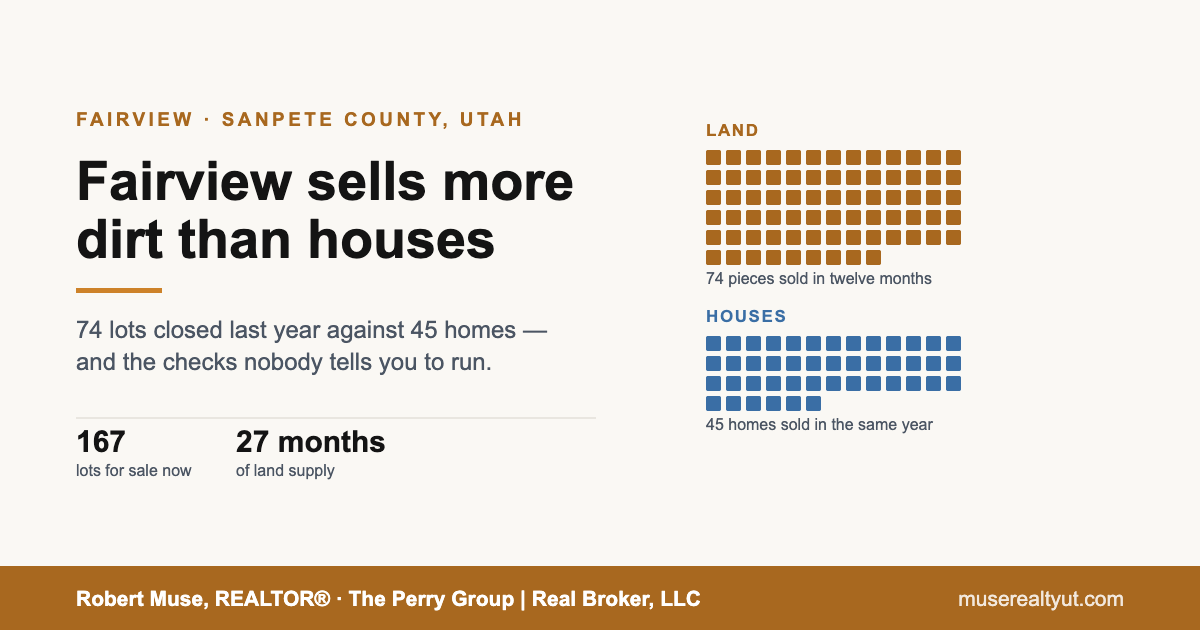
Fairview sells more dirt than it sells houses. Over the twelve months ending September 24, 2026, 74 pieces of land closed in ZIP 84629 against 45 homes. That ratio is the first thing you need to understand about this market, because almost every assumption a Wasatch Front buyer brings up the canyon is built for the other kind of transaction.
Land and residential sales in ZIP 84629 closed September 24, 2025 – September 24, 2026. Source: UtahRealEstate.com / Wasatch Front Regional MLS. Pulled September 24, 2026.
ZIP 84629 is much bigger than Fairview city. The town itself had 1,203 residents at the 2020 Census. The ZIP takes in Milburn, Indianola, the ground up Fairview Canyon and Skyline Mountain Resort, a gated recreational subdivision a few miles southeast of town. Most of the lots you will see for sale are up there or nearby, which is why this article is mostly about buying land and not about buying a house.
The market is telling you to slow down. Listen to it.
There are currently 167 pieces of land listed for sale in 84629. At the rate land has been closing, that is roughly twenty-seven months of supply. The lots that are sitting have been sitting: the median days on market across active land listings is 125 days.
Houses are tighter but not tight. Fifty-one homes are listed against 45 sales in the last year — about fourteen months of supply, with a median of 101 days on market for what is currently listed.
Active listings in ZIP 84629 as of September 24, 2026; sold figures for the twelve months ending the same date. Source: UtahRealEstate.com / Wasatch Front Regional MLS.
There is one more number worth sitting with. The median sold price for a home here over the last year was $378,000. The median asking price of what is on the market right now is $549,000. Those are two different sets of houses and it is not a clean comparison — but a gap that size usually means a meaningful share of the standing inventory is priced at a number the market has not been paying.
For contrast, Richfield, down US-89 in Sevier County, sold 75 homes in a near-identical twelve-month window at a median of $320,000, and its busiest price band cleared in a median of twelve days. Two central Utah towns, two completely different clocks. Ephraim, twenty miles down the valley, runs on a third.
Split the lot market by price and the intuition breaks. The cheapest third — everything under $100,000, which is where nearly two thirds of the listings sit — is carrying about thirty months of supply. The lots above $250,000 are carrying about seventeen. Cheap ground here is not moving quickly. There is simply a great deal of it, and the checks below are how you work out which pieces are the ones that will not sell again.
If you want to see what is actually on the market in the town itself rather than across the whole ZIP, that sits on the Fairview area page.
None of that is a reason to stay away. It is a reason to take the time the market is giving you, because the checks below are the difference between a lot you can build on and a lot you cannot.
Start with water. It is the one you cannot fix later.
This is the item that surprises people most, so I am putting it first.
Fairview sits in Water Rights Area 65, the San Pitch River drainage, which is part of the Sevier River Basin. The surface waters of that basin were closed to new appropriations by a governor’s proclamation in 1946. The groundwater was closed to new appropriations in 1997. There are narrow exceptions written into the basin’s groundwater management plan, but supplying a new house is not one of them.
In practice: you cannot simply apply for a permit and drill a well. To divert and use water in Utah you have to own a water right, and in a closed area you cannot file a new one. You have to acquire an existing right, or a share of one, and then get a change application approved by the State Engineer to move the point of diversion, the place of use and the nature of the use to your lot. That is a real process with a real timeline and a real chance of denial. Utah has no exempt domestic well allowance — there is no small-user exception that lets you skip it.
Rainwater does not solve it either. Utah lets you collect rainwater in two covered containers of no more than 100 gallons each without registering, or up to 2,500 gallons total if you register free with the Division of Water Rights. That is a storage cap, not a water supply, and it will not carry a household.
So the question on any lot without a culinary connection is not “can I get water” but “what specific water right comes with this, and is it already approved for use here?” Get the water right number. Look it up yourself on the Division of Water Rights search. If the answer involves an underground water claim or a diligence claim, understand that those are assertions of pre-1935 or pre-1903 use that remain unproven until a general adjudication confirms them.
Inside Skyline Mountain Resort there is a public utility, which changes the picture — but only for part of the resort. Culinary water there is supplied by the Skyline Mountain Special Service District, a separate public entity, not by the property owners association. I asked the district directly, and the answer is worth setting out in full.
Start with the part that removes an option altogether. No wells may be drilled anywhere inside the district’s boundaries or on Skyline Mountain Resort property. Not difficult, not a matter of finding a right to buy and changing it — not permitted. On a resort lot there is no third path. It is a district connection or it is hauling.
Lower-area lots can connect to the system. The district puts the connection fee at $2,000 to $3,000, depending on whether the setter is already in place, and monthly billing at $73, which includes a base of 8,000 gallons with tiered pricing above that.
The upper mountain and Birch Creek have no direct connection at all. Owners there haul water from one of two fill stations — one at Thad’s Peak Well, the other down in the lower area by the upper gate. Monthly billing is $18 for an improved lot and $12 for a lot with no improvements.
If you are looking at an upper-mountain lot, read that again, because it is the most consequential sentence in this article. You would be hauling your water. Set it beside the association’s rule that no upper roads are plowed and the shape of the thing is clear: no tap, and no ploughed road to haul along for several months of the year.
One more figure, and it is a large one. The district charges a $10,000 impact fee on any new house, cabin or other habitable structure, payable in full before the county will approve a building permit. That is not a cost you can defer to closing or to later — it stands between you and the permit.
There is no waiting list at the time of writing. And note that the district’s lower-versus-upper line and the association’s plowed-versus-unplowed line are drawn by two different organisations. Do not assume they fall in the same place. Ask both, about your specific lot.
One more thing the association flagged, and it matches what the district told me: water is bought from the district monthly, and the rate depends on where the lot is and whether it has been hooked up. An unconnected lot is not automatically a lot with no water bill. Ask the district what the monthly charge is on your specific parcel, connected or not.
Fees and billing supplied by the Skyline Mountain Special Service District, September 2026, and described by the district as subject to change. Confirm current figures with the district on 435-469-1661 before relying on them.
Then slope, because slope decides whether you get a septic system
No culinary sewer means an onsite wastewater system, and in Utah those are governed by rule R317-4. The constraints are specific and you can check most of them before you spend a dollar:
- Above 35% slope, you cannot put an absorption system in at all. Between 25% and 35% it takes additional conditions including a professional engineer’s report. That single rule disqualifies a lot of pretty hillside ground.
- A conventional system needs suitable soil at least 48 inches below the bottom of the dispersal system before you hit bedrock, impervious strata or excessively permeable material. On rocky canyon lots that is frequently where it ends — though an alternative system has different requirements and may still work, at a different price.
- You need a 100% replacement area. Every property using an onsite system has to hold a full second absorption area in reserve. Your buildable footprint is smaller than the lot looks.
- Setbacks eat the rest. An absorption system has to sit 100 feet from a culinary water source, 100 feet from a watercourse, and 100 feet from a lake, pond or reservoir.
- Percolation has to land in a window. Faster than one minute per inch is excessively permeable; slower than 60 minutes per inch will not support a conventional system.
Permits in Sanpete County are issued by the Central Utah Public Health Department, not by the county building department, and the soil and percolation work has to be done by a certified onsite wastewater professional. Their published fees at the time of writing are $600 for a conventional system and $900 for an alternative one — but the cost that matters is the design and installation on difficult ground, which is a different order of magnitude.
The honest version: a feasibility determination before you close is cheap relative to the lot. If a seller will not allow one, that tells you something.
Find out exactly which roads get plowed
“Year-round access” is a phrase that means different things a mile apart in this area.
SR-31 through Fairview Canyon is not a seasonally closed route. The nine highways UDOT gates every winter do not include it. But it climbs over a high summit on the Wasatch Plateau, and it closes without notice, sometimes for days, for avalanches, storms and debris flows. Open all year is not the same as reliable all year.
Skyline Drive is a different story. The Forest Service lists North Skyline Drive as closed in winter and opening in May, and a current-conditions note as recently as late May 2026 read “not passable due to snow.” South Skyline Drive also lists a May season with the caveat that weather and snowmelt determine the dates, and it requires high-clearance four-wheel drive. In winter these become groomed snowmobile routes. If a lot’s access depends on Skyline Drive, it is a summer lot.
Inside Skyline Mountain Resort, plowing is not uniform. The association’s published rules provide for plowing the roads in what it calls the “full time area” and state plainly that no upper roads are to be plowed, with snow gates limiting upper-area winter travel to tracked vehicles. The resort covers roughly 1,500 acres with about 35 miles of private roads, and no owner or contractor may perform maintenance on them without board permission. So the question on any lot there is not whether the resort plows — it is whether your particular lot is inside the full-time area. Get that answer in writing from the association before you write an offer.
The office names the year-round sections as A, B, C, GC and E. The plowed area is everything below the snow gates. Above the gates, winter access is by tracked vehicle after a snowfall. The office added that a few lots in sections M and D may also be year-round, but was explicit that this has to be checked lot by lot rather than assumed. So if the lot sits above the gates, or anywhere in M or D, get the answer in writing for that parcel before you write an offer.
A caution on that: the rules manual published online dates from the 2000s. I asked the association office directly. The current governing documents are the 2015 CC&Rs, and the office will send those and the current Rules and Regulations on request. Ask for both. Do not rely on the twenty-year-old manual, and do not rely on me — verify it for your lot.
The office also gave me the current costs. Dues are $60 a month. Common area taxes vary by lot and run somewhere around $40 a year. The transfer fee at closing is $500, dropping to $50 if the buyer already owns property in the association. Put the transfer fee in your closing cost estimate, because it is the one buyers routinely do not see coming.
Golf course lots carry their own construction requirements, different from the rest of the resort. If you are looking at a GC lot, that is another question for the office with a specific parcel in hand.
More generally, for any lot on a private road: find the recorded easement or plat dedication that gives you legal access from a public road to your boundary. Check whether the access road appears on Sanpete County’s public access roads map or is private. If it is private, read the recorded maintenance agreement or CC&Rs and find out who plows, who repairs, and how the cost is assessed. Utah recognises prescriptive access, but a prescriptive claim takes twenty years of open, adverse, continuous use to establish, it is proven by clear and convincing evidence, and it generally does not obligate the burdened owner to maintain anything. And access across national forest or state land is not automatic just because there is no other way in.
Assume you are in the wildland-urban interface
Sanpete County has adopted the Utah Wildland-Urban Interface Code with local amendments and maintains a WUI map. The county’s own guidance is that cabins and homes near the base of the mountain, on the benches or on the mountain typically fall inside it. What that means in practice:
- Class 1 ignition-resistant construction for new buildings in WUI areas, with narrow exceptions.
- No structure within 30 feet of a property boundary, plus a managed defensible-space zone from 30 to 50 feet — extended a further foot per degree on descending slopes steeper than 20 degrees. On a small lot, that plus the septic setbacks can leave less room than you think.
- New subdivisions of two or more lots need a water supply of 2,000 gallons per lot within 1,000 feet of the structures, at an accessible site near the roadway.
There is also a new cost. Under HB 48, passed in 2025, the state maintains an official high-risk WUI boundary and counties assess an annual fee on high-risk WUI property owners, beginning January 1, 2026, based on the square footage of the structure. Note the word structure: a bare lot with nothing on it is not assessed, so this is a cost that arrives when you build rather than when you buy. The state has described the initial 2026–27 fee as falling in a $20 to $100 range per structure. You can check a parcel’s status yourself at the state’s wildfire risk site before you buy.
And there is an insurance question that did not exist five years ago. Utah had the highest homeowners insurance nonrenewal rate in the country in 2025 — about 4.5% of policies, roughly one in twenty, up from 1.73% the year before, according to National Association of Insurance Commissioners data reported in September 2026. I am not going to tell you what that means for your specific property, because it depends on the carrier and the parcel. I will tell you that you should get a written insurance quote on a specific address before you remove contingencies, not after, and that this is now a real step and not a formality.
The money works differently than it does on a house
Four things that catch people out, all of them structural rather than negotiable:
- A conforming mortgage does not exist for raw land. Fannie Mae will not buy or securitise a loan secured by vacant land, so the usual secondary market is closed to it and a lot loan is typically a bank portfolio product on that bank’s own terms.
- Expect a lender to ask for roughly a third down. Federal interagency guidance sets a supervisory loan-to-value limit of 65% on raw land and 75% on land development, against 85% on improved property. Those govern a bank’s portfolio rather than any single loan, and they can be exceeded — but they are why land-loan down payments cluster where they do.
- Building the cabin does not automatically fix it. Fannie Mae’s ineligible list also includes properties that are not readily accessible by roads meeting local standards, and properties not suitable for year-round occupancy. A finished cabin on an unplowed private road can still fall outside conventional financing — which matters when you go to sell it, because it narrows your buyer pool to the same cash and portfolio lenders you had to use.
- The property tax is meaningfully higher than on a primary home. Utah’s primary residential exemption takes 45% off fair market value, so a primary residence is taxed on 55% of its value. That exemption attaches to a primary residence and up to one acre. A vacant lot has no residence for it to attach to, and the Tax Commission is explicit that a second or unoccupied residence is taxed on 100% of fair market value. Confirm the treatment of your specific parcel with the Sanpete County Assessor, but budget for the full number, not the discounted one.
I am a REALTOR, not a lender, a tax adviser or a lawyer. Those are the structural facts; what they mean for your finances is a conversation to have with the people licensed to have it.
The order I would actually do this in
- Water first. Either a water right — get the number, look it up, confirm it is approved for use on that parcel — or a district connection. Inside the resort a well is not an option at all, so ask the district which side of the line your lot sits on, and budget the $10,000 impact fee if you intend to build. If there is no right and no connection, everything below is moot.
- Slope and a septic feasibility determination. Before the money gets serious. Ask specifically about slope percentage, depth to bedrock, and whether a 100% reserve area fits.
- Legal access, in the recorder’s records. Not a listing description, not a dirt road you drove. A recorded easement or plat dedication.
- Plowing, in writing. Which roads, by whom, paid for how, and is this lot inside the plowed area.
- Power. Confirm the provider for that exact parcel — Fairview City runs its own municipal electric utility, and other providers operate nearby, so it is not a safe assumption. Then ask that utility, in writing, what allowance it puts toward a residential line extension and what the applicant pays beyond it — poles, conductor, engineering and trenching add up quickly on a lot any distance from existing distribution.
- WUI status and an insurance quote. Both on the specific address, both before contingencies come off.
- Call Sanpete County Planning & Zoning. The county has a sensitive lands zone covering the mountain and canyon ground, a subdivision ordinance that bars subdividing land subject to slides, rockfall, avalanche or shallow water table until the hazard is eliminated, and occasionally access-specific restrictions — as of September 2026 the county listed a moratorium on new permits for projects accessing Pine Creek Road. Ask what applies to your parcel today.
If you want a second opinion on a specific lot
I work Sanpete County, Sevier County and southern Utah County. If you send me a parcel number or an address, I will tell you what the comparable sales actually say, what I would ask the seller, and where I think the risk sits — including when I think you should walk.
There are 167 pieces of land for sale in this ZIP and the ones sitting there have a median of about four months on the market. You have time to do this properly. Get in touch here.
Market statistics from UtahRealEstate.com / Wasatch Front Regional MLS for ZIP 84629: land and residential sales closed between September 24, 2025 and September 24, 2026, and active listings as of September 24, 2026; pulled September 24, 2026. Population from the U.S. Census Bureau (2020 Census). Water rights policy from the Utah Division of Water Rights, Area 65. Onsite wastewater requirements from Utah Administrative Code R317-4 and the Central Utah Public Health Department. Road status from UDOT and the USDA Forest Service, Manti-La Sal National Forest. Wildland-urban interface requirements from Sanpete County and Utah HB 48 (2025). Nonrenewal figures from National Association of Insurance Commissioners data as reported September 2026. Financing standards from the Fannie Mae Selling Guide and the federal Interagency Guidelines for Real Estate Lending Policies. Property tax treatment from the Utah State Tax Commission. Skyline Mountain Resort details from the resort’s published rules; water connection, billing, impact fee and well-drilling policy from correspondence with the Skyline Mountain Special Service District, September 2026, with fees described by the district as subject to change. Richfield comparison figures are for residential sales in ZIP 84701 closed September 19, 2025 – September 19, 2026, same source. Information deemed reliable but not guaranteed and not verified by broker or MLS. Nothing here is legal, tax, insurance or investment advice. Association governing documents, dues, transfer fee and winter-access sections supplied by the Skyline Mountain Resort office, September 2026, and described as current at that date.